1887 ANTIQUE MAP OF PENNINE ALPS / SWITZERLAND ITALY / AOSTA
Check the listing for details.


| Location | Montreal, Quebec CA |
| Shipping | USD 5 · Flat |
| Seller |
montrealmaps
100% positive · 7675 feedback
|
| Listing | FixedPriceItem · Active |
| Start time | 2024-08-23T13:13:31.000Z |
| End time | 2024-09-23T13:13:31.000Z |
| Time left | P24DT22H31M57S |
| Return shipping will be paid by | Seller |
| All returns accepted | Returns Accepted |
| Item must be returned within | 60 Days |
| Refund will be given as | Money Back |
| Date Range | 1800-1899 |
| Year | 1887 |
| City | AOSTA |
| Country/Region | Italy, Switzerland |
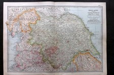
ORIGIN OF THE MAP: "Switzerland", 12th edition, published in Leipzig, Germany by Karl Baedeker and London, England by Dulau and Co. DATE OF ISSUE: 1887. SIZE: The sheet measures: SIZE: 9" x 6" (22.5 x 15 cm). Most of maps we sell come from ancient atlases that were damaged and beyond repair. The maps have often a canvas or paper binding tape mounted on back along the centerfold. If you have ANY PROBLEM with the purchase, it is essential you CONTACT US BEFORE LEAVING FEEDBACK TO GIVE US THE CHANCE TO RESOLVE IT. SHIPPED FROM CANADA in secure tubes or bubble mailers. PLEASE NOTE, THAT THE SHIPPING FROM QUEBEC TO THE U.S. TAKES 10 DAYS / WORLD 18 DAYS. WE COMBINE SHIPPING COST FOR MULTIPLE ITEMS: THE POSTAGE FEE IS CHARGED FOR THE FIRST ITEM ONLY. MONTREALMAPS EBAY STORE PLEASE CONTACT FOR MORE DETAILS!